Winter service · New York
Winter service in Syracuse
What winter is really like in Syracuse: about 128 inches of snow a year — the most of any US metro — built from many smaller lake-effect falls off Lake Ontario and the Tug Hill, the Golden Snowball rivalry with Buffalo, and the unusual municipal program under which the City, not the property owner, clears the sidewalks.
What winter actually does in Syracuse
Syracuse is, by the numbers, the snowiest big city in America — it receives the most annual average snow of any metropolitan area in the United States, about 128 inches a year at the airport. It sits in Central New York at the south end of Onondaga Lake, spreading from the low ground by the water up onto higher land: to the north the country is flat, but to the south it rises fast into hills, climbing toward 1,500 feet only a few miles out. That shape, and the big lake to the north, are what make the winter.
The snow is lake-effect off Lake Ontario, and what sets Syracuse apart from the other Great Lakes snow cities is the Tug Hill Plateau to the north-east. Cold air crossing 150 miles of open Ontario water loads up with moisture, and then the land itself does the rest: as the bands reach the plateau they are lifted over rising ground, cool further, and dump. The result, for the city, is not so much the single monster storm as a winter that simply keeps snowing — January alone averages about 34 inches, and measurable snow falls on roughly 65 days a year. Skies are grey and overcast for much of it. This is a place where the work is not waiting for a storm; it is keeping up with a season.
Lake Ontario, the Tug Hill, and the shape of the snow
It is worth being precise about the Tug Hill, because its numbers are famous and easy to misattribute. The plateau — the towns of Redfield, Montague, Osceola and Worth, east of the lake — is genuinely one of the snowiest places in the eastern US, its core averaging well over 200 inches a year; in a single February 2007 event Redfield took about 141 inches in ten days, roughly double what fell nearer the shore. New York’s snowiest season on record, 466.9 inches, was measured up there, at Hooker.
But those are plateau figures, not city figures. Syracuse gets a heavy, steady share of Lake Ontario’s output — enough to lead the country’s metros — without the plateau’s extremes. The honest picture is a city on the edge of the snow country: the higher ground south and east takes noticeably more than the low downtown and lakeshore, so even within the metro the totals vary with the land. For anyone planning routes, that gradient — light in the flats, heavier as you climb — is the local pattern to know.
The Golden Snowball — and how Syracuse differs from Buffalo
Upstate New York turns its snow into a contest. The Golden Snowball Award tracks the season’s snowfall across the five biggest cities — Syracuse, Buffalo, Rochester, Binghamton and Albany — and hands the title to the snowiest each spring. Syracuse is the most successful of them, and won again in 2025–26 with 143.1 inches. It is lighthearted, but it points at a real difference in how these cities get their snow.
The contrast with Buffalo is the sharp one, and it is not just bragging rights. As the contest’s own organisers put it, Buffalo depends on amassing huge totals from a few big lake-effect storms, while Syracuse builds its total from many smaller snowfalls throughout the winter. Buffalo’s snow comes off Lake Erie onto the hilly Southtowns; Syracuse’s comes off Lake Ontario, lifted by the Tug Hill. Their record seasons are almost neck and neck — Buffalo’s 199.4 inches in 1976–77 against Syracuse’s 192.1 inches in 1992–93 — but the everyday experience is different: Buffalo braces for the event, Syracuse manages the grind. That difference in rhythm is, in practice, a difference in how you staff and plan a winter. And as the next section shows, the two cities have taken opposite approaches to the one surface everyone argues about — the sidewalk.
What the local rules say — the city clears the sidewalks
Here Syracuse does something unusual for an American city: it clears the sidewalks itself. In June 2021 the Common Council approved a Municipal Sidewalk Program, taking the job from individual property owners after years of a complaint-and-fine model that, by the City’s own account, simply left too many walks impassable. Rather than keep fining owners who did not shovel, the City decided the walks were public infrastructure worth clearing the way roads are.
The program is paid for by an annual sidewalk fee — phased in to roughly $100 a year for a home and $300 for commercial property — and organised into four districts along the public-works quadrants, with the money raised in each district staying there and with hardship assistance for those who need it. The whole thing was estimated at around $4.5 million a year. The practical upshot is close to the opposite of Buffalo across the state, where the owner is the one responsible for the sidewalk: in Syracuse, that sidewalk is the City’s to clear, funded by a fee the owner pays. None of this is legal advice — the older owner-responsibility rules sat in the City’s Chapter 24 and the program changed the arrangement in practice; the point here is simply how the city now approaches it.
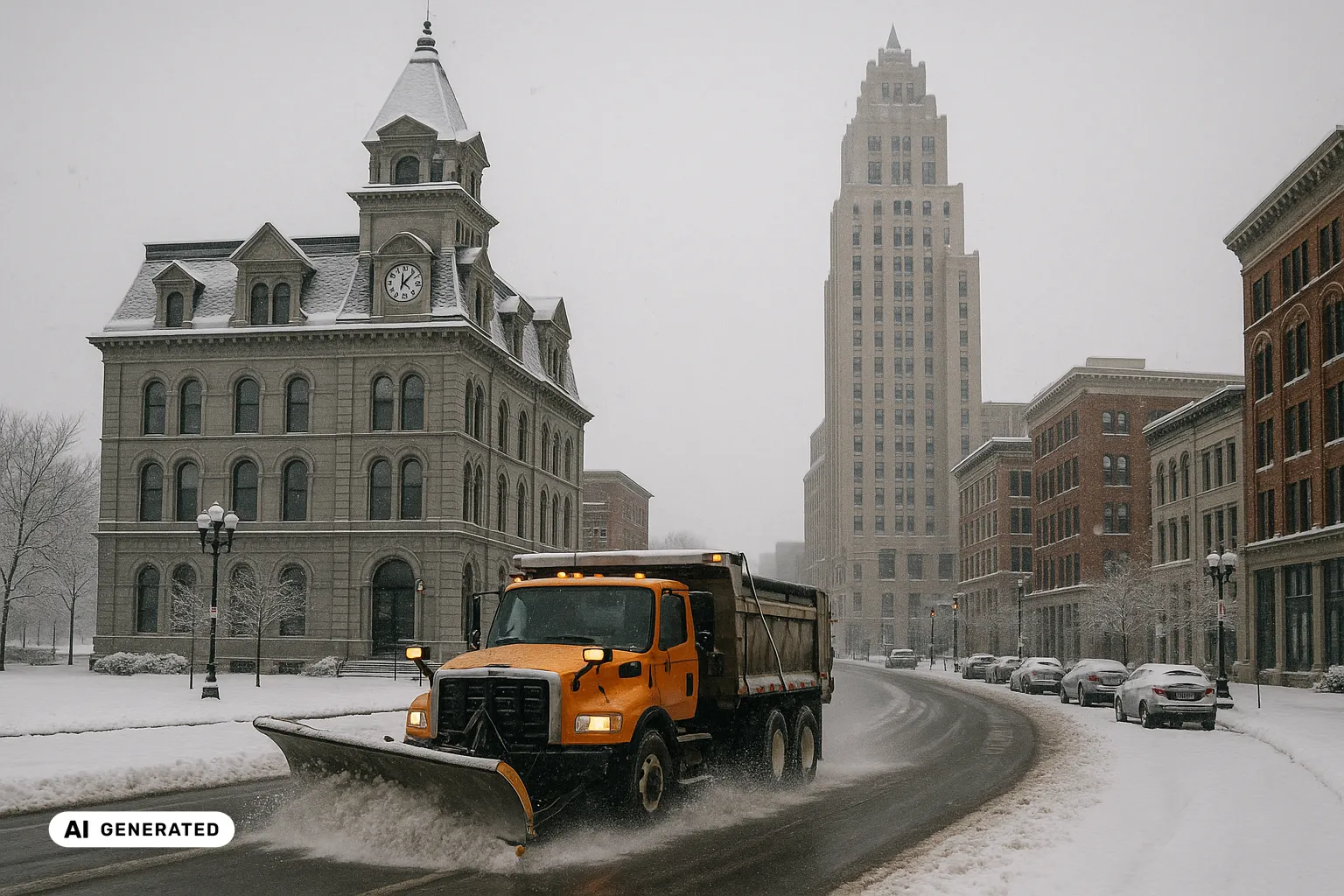
How the city plows — and the I-81 rebuild
On the roads, the Department of Public Works runs a fleet of around 40 plows and, notably, a public plow-tracker map that updates several times an hour, colour-coding each street by how recently it was cleared — green for the last hour, blue for the last three. Plowing goes by priority: emergency routes and main streets first, around hospitals and business corridors, then the residential grid, with a target of reaching every street within 24 hours of a snow event. In a winter that snows this often, that target lives under steady pressure, which is part of why the City put the map online in the first place — it cut the volume of “where’s my plow” calls sharply.
Two local features complicate the map. University Hill — Syracuse University, Upstate Medical, and the city’s fastest-growing neighbourhood — sits on grades with heavy foot traffic, the kind of slope-plus-pedestrians combination that ices first and matters most. And the I-81 viaduct through downtown is mid-way through a $2.25-billion replacement, swapping the elevated highway for a street-level “community grid”; it broke ground in July 2023 and runs about six years, which means shifting work zones and changing traffic patterns through the core for several winters yet. The interstates themselves — I-81, I-690, I-481 and the I-90 Thruway — are county and state responsibilities, not the City’s, so which crew is clearing a given road here depends, as ever, on whose road it is.
Onondaga County and the snow country around it
Syracuse is the seat of Onondaga County, and its immediate neighbours run their own local roads and rules: Salina with the village of Liverpool, DeWitt, Cicero, Clay, Camillus, Geddes and Manlius among them. To the north — where the huge Micron semiconductor complex is planned in Clay — the land is flat and the growth is fast, in some of the most reliably snowy country in the state. Beyond, on the plateau, the Tug Hill towns mark the extreme end of the same snow that reaches the city, and across Upstate the Golden Snowball neighbours — Buffalo, Rochester, Binghamton and Albany — share the season’s weather from a friendly distance, though Albany, the state capital down in the Hudson Valley, gets its snow from nor’easters rather than a lake and stays the least snowy of the five. Cross any of those lines and the totals, the crews and the rules change with them.
Keeping the record straight
In a city where the snow is not an event but a season — sixty-odd days of it, a plow target measured against every storm, sidewalks now cleared by the City itself — the useful thing is being able to show, plainly, what was done and when. Not to win an argument, but because a winter this relentless generates exactly the questions a vague answer cannot settle: was the route cleared, when, in what conditions. A simple, time-stamped record of each treatment, set against what the weather was actually doing, turns “we were out all night” into something specific. That is the documentation support Wintertrace is built to make easy — a clear log of where a crew went and when — whether you look after a single property on University Hill or a run of routes across Onondaga County. It does not change whose sidewalk is whose; it just means that when someone asks what happened during the last stretch of snow, the answer is on file. Not a substitute for legal advice.
Local facts
- Syracuse receives the most annual average snow of any metropolitan area in the United States — about 128 inches (roughly 325 cm) a year at the airport, on the NCEI 1991–2020 normals. Source
- The snowiest months are January (about 34 inches), December (about 31 inches) and February (about 30 inches), with measurable snow on roughly 65 days a year. Source
- The snowiest season on record was 1992–93 with 192.1 inches, and the snowiest single month was January 2004 with 78.1 inches; the record low is −26 °F (−32 °C), reached three times since 1942. Source
- Syracuse sits in Central New York at the south end of Onondaga Lake, between about 380 and 440 feet of elevation; the land to the north is generally flat, while to the south it rises quickly into hills — a few miles south, ground climbs to around 1,500 feet. Source
- Its snow is lake-effect off Lake Ontario, roughly 50 km to the north, and is amplified by the Tug Hill Plateau north-east of the city, where snowfall averages more than 200 inches a year as bands are lifted over rising ground. Source
- The orographic lift is dramatic in the surrounding plateau, not the city itself: in one February 2007 event the plateau town of Redfield took about 141 inches in roughly ten days — about twice what fell nearer the lake shore. Source
- The Golden Snowball Award is the annual contest between the five biggest Upstate New York cities — Syracuse, Buffalo, Rochester, Binghamton and Albany — for the most seasonal snow; Syracuse is the most successful of them and won again in 2025–26 with 143.1 inches. Source
- The recognised difference between the two rivals: Buffalo amasses huge totals from a few big lake-effect storms, while Syracuse builds its total from many smaller snowfalls across the whole winter. Source
- Their record seasons are close — Buffalo's 199.4 inches (1976–77) against Syracuse's 192.1 inches (1992–93), with Rochester's 161.7 inches (1959–60) behind both. Source
- Unusually for a US city, Syracuse clears sidewalks itself: the Common Council approved a Municipal Sidewalk Program on 7 June 2021, taking the job from individual property owners after years of a complaint-and-fine model that left many walks impassable. Source
- The program is funded by an annual sidewalk fee — phased in to about $100 a year for residential and $300 for commercial properties — is organised into four districts along the public-works quadrants, and was estimated at roughly $4.5 million a year, with hardship assistance. Source
- On the roads, the City of Syracuse Department of Public Works runs a fleet of around 40 plows and a public GIS plow-tracker map that updates several times an hour, colour-coding each street by how recently it was cleared. Source
- Plowing runs by priority — emergency routes and main streets first, around hospitals and business corridors, then residential streets — with a target of reaching every street within 24 hours of a snow event. Source
- The interstates through the city — I-81, I-690, I-481 and the I-90 Thruway — are county and state responsibilities; the elevated I-81 viaduct through downtown is being replaced by a street-level 'community grid' in a $2.25-billion NYSDOT project that broke ground in July 2023 and runs for about six years. Source
Official contacts
-
City of Syracuse — Municipal Sidewalk Program
The program under which the City, rather than the property owner, clears public sidewalks — how it works and how the sidewalk fee funds it.
-
City of Syracuse — Plowing and snow plow map
How the DPW plows the streets, the priority order, and the public plow-tracker map that shows what has been cleared.
-
City of Syracuse — Winter service requests
Where residents report an unplowed street, an uncleared sidewalk or another winter issue to the City.
-
The State's overview of the I-81 rebuild through downtown Syracuse — the source of years of shifting work-zone traffic patterns.
Common questions about winter service in Syracuse
- Is Syracuse really the snowiest city in the United States?
- Among big cities, yes. Syracuse receives the most annual average snow of any metropolitan area in the US — about 128 inches a year at the airport on the 1991–2020 normals — and it usually wins the Golden Snowball, the annual contest between the largest Upstate New York cities. It is snowier on average than Buffalo, though the two are close and Buffalo holds the higher single-season record. Snow is a genuine part of the city's identity here, not an occasional event.
- Do I have to shovel my own sidewalk in Syracuse?
- Here the answer is unusual for an American city: the City itself clears the sidewalks. In 2021 the Common Council approved a Municipal Sidewalk Program, taking the job from individual property owners after years of a complaint-and-fine system that left many walks impassable. The program is paid for by an annual sidewalk fee — phased in to roughly $100 a year for a home and $300 for commercial property — and organised into four districts, with hardship assistance. So the practical picture is close to the opposite of many US cities: the sidewalk in front of your building is the City's responsibility to clear, funded by a fee you pay. This is general information, not a substitute for legal advice.
- How is Syracuse's snow different from Buffalo's?
- Different lake, different terrain, different rhythm. Buffalo's snow comes off Lake Erie and piles onto the hilly Southtowns south of the city, usually in a few enormous lake-effect storms. Syracuse's comes off Lake Ontario and is amplified by the Tug Hill Plateau to the north-east, and it arrives as many smaller falls spread across the whole winter. That is why Syracuse can be the snowier city on average while Buffalo holds the bigger single-storm reputation. And the two handle sidewalks in opposite ways — Syracuse clears them municipally, Buffalo leaves them to owners — so even a contractor who knows one city cannot assume the other.
- What is the Tug Hill Plateau, and does all that snow fall on the city?
- The Tug Hill is a plateau east of Lake Ontario and north-east of Syracuse, and it is one of the snowiest places in the eastern US — its core averages well over 200 inches a year, because lake-effect bands crossing 150 miles of open water are then lifted over rising ground and wrung out. But those extreme totals belong to the plateau towns like Redfield and Montague, not to Syracuse itself. The city gets a heavy, steady share; the record-book numbers you may read — 300-plus-inch averages, a 466-inch season — are the surrounding snow country, and it matters to keep the two apart.
- How quickly does the city plow, and can I see where the plows are?
- The Department of Public Works runs about 40 plows and a public plow-tracker map that updates several times an hour, colour-coding each street by how recently it was cleared. Plowing goes by priority — emergency routes and main streets first, especially around hospitals and business corridors, then residential streets — with a target of reaching every street within 24 hours of a snow event. In a steady lake-effect winter that target is under constant pressure, which is part of why the City put the live map online.
- What is the Golden Snowball?
- It is a friendly annual contest between the five biggest Upstate New York cities — Syracuse, Buffalo, Rochester, Binghamton and Albany — for the most snow in a season, tracked through the winter and awarded in spring. Syracuse is the most successful city in it and won again in 2025–26 with 143.1 inches. It is lighthearted, but it captures something real about the region: for these cities, the amount of snow is a point of identity, and the year-to-year rivalry with Buffalo in particular is followed closely.
- Why are University Hill and the downtown grades tricky in winter?
- Syracuse spreads from the low ground by Onondaga Lake up onto higher ground, and University Hill — home to Syracuse University and Upstate Medical University, and the city's fastest-growing neighbourhood — sits on a rise with real grades and heavy foot traffic. Slopes lose grip first in a freeze, and a hillside with tens of thousands of pedestrians a day is a demanding place to keep clear. The low-lying downtown and lake shore are a different problem again — flatter, but exposed.
- Is the I-81 construction going to affect winter driving?
- For some years, yes. The elevated I-81 viaduct through downtown is being replaced by a street-level 'community grid' in a $2.25-billion state project that broke ground in July 2023 and runs about six years. That means shifting work zones and changing traffic patterns through the core and on the approaches to University Hill for several winters — worth factoring in for anyone whose routes cross downtown, since the road layout itself is a moving target during the rebuild.
Documenting winter service in Syracuse
Anyone clearing snow and ice in Syracuse may later need to show when and where a route was treated. Wintertrace is open-source software that records exactly that — time, location and weather for each run — as a calm basis for your own operational records and service proof. It is not a substitute for legal advice.
This overview is for general information and is not legal advice. Local rules on snow and ice clearing vary — the wording of the local rule and the responsible authority always govern.